Durango, CO

Durango, CO

Durango is a fantastic small town located in southwest Colorado with so much to do. There is no way we can cover everything here, so we will focus on some of the highlights of our trip.

Going to Durango, CO for a long weekend? Follow our footsteps! Above is a Map of places we visited! Everything shown here is within a couple hours’ drive from Durango.

Purgatory Ski Resort

This is a great place to set up your base camp. The ski resort had several events going on while we were there during the summer. Our guess is that it’s a solid place to ski in the winter! Our hotel had access to an included sauna and hot tub. Durango is an expensive town and we found summer prices at Purgatory were less compared to Durango.

Ouray, CO

Ouray, CO is the farthest north we cover. Ouray is known as the “Swiss of the Americas” and didn’t disappoint. The area has some incredible mountains, beautiful waterfalls, and awesome hot springs. They have dedicated pool areas for the hot springs so bring a bathing suit!  Cascade Falls (pictured) was one of the hikes in the area.  Cascade Falls is a short hard hike, but it follows a picturesque creek and has an option to continue to climb higher for more views. Free parking is provided.

Bear Creek Falls (View Only)

This view is right outside of Ouray. It is a quick park and stop along the highway for some amazing pictures. Free Parking is provided.

Little Molas Lake

Little Molas lake is right off the main highway. It is a small lake nestled in the mountains and is incredibly beautiful. There are several hikes that start here with camping spots along the way. We suggest that you take time to find a path to hike. Free parking is provided.

Molas Pass

Molas Pass is another quick stop along the highway. There are free public bathrooms here for anyone to use. Take a moment to take a few pictures of this amazing view! Free parking is provided.

Our picture provided was from a different trip we took in April the year before.

Potato Lake

MUST SEE (If road allows):

Potato Lake (or Spud Lake) is one of our favorite hikes in Durango. The trailhead is located 2.8 miles down Lime Creek Road which is a rocky dirt road. We suggest getting a crossover sized vehicle or larger to attempt this road. There are plenty of rocks to bottom out your vehicle and plenty of opportunities to get your vehicle stuck in the mud if the road is wet.

The trailhead parking lot is not well marked but is still very apparent. There are plenty of places to park for free off to the left of the road. The trailhead and trail are both well marked and Once you get on the trail, you will see forest area, small creeks, views of the surrounding mountains, and at the top a beautiful view of the lake (pictured). The trail is an easy to moderate hike and is 2 miles round trip.
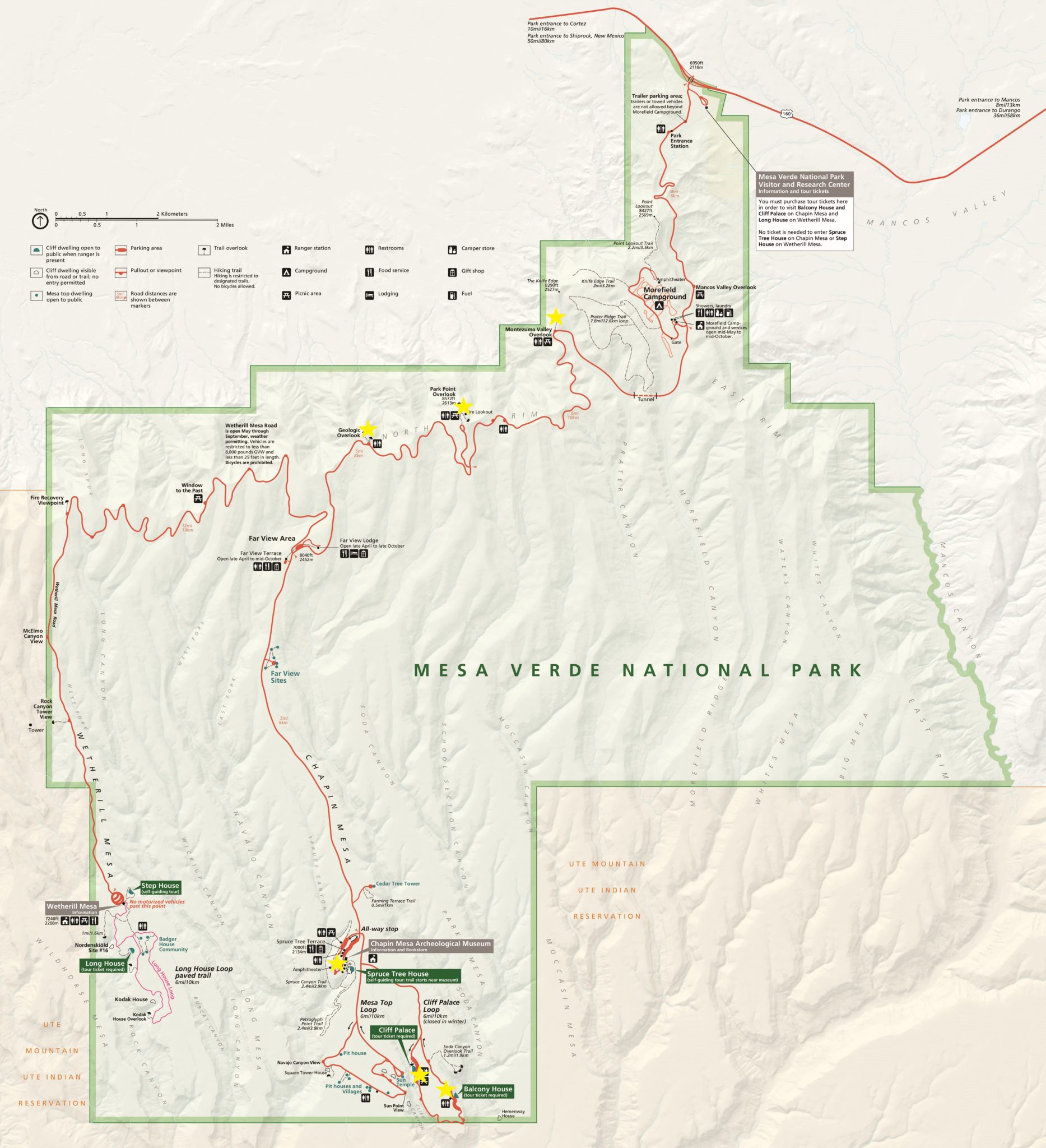
Mesa Verde

MUST SEE:

Entrance Fee: $15 per Vehicle
Stop at the Visitor Center for a map and tickets to enter the cliff dwellings.

Mesa Verde is a National Park near Durango. The drive itself changes from a temperate forest to a semi-arid desert in just a 36 mile drive. The park is filled with amazing views and a fascinating history. The park was established in 1906 to preserve the archeological heritage of the Pueblo people.

In Mesa Verde, you can see overlooks of the beautiful surrounding area, amazing wildlife, and the archeological evidence leftover from when the Pueblos inhabited the area. The park protects 5000 archeological sites including 600 cliff dwellings.

Overlooks

There is no lack of views from Mesa Verde. Three of the main views are marked on the provided Mesa Verde map along the top. All of the marked views offer free parking, a restroom, and a short hike.

Balcony House

MUST SEE:

Ticket Fee: $5/person
Buy tickets at visitor center before entering the park.

The Balcony House is known as the adventurous cliff dwelling. You can see this cliff dwelling by tour only. You will be able to hike down below the cliff dwelling and climb a ladder to actually go into the dwelling. Parking to see this dwelling is free and you will meet your tour guide at the entrance to the hike.

Cliff Palace

MUST SEE:

Ticket Fee: $5/person
Buy tickets at visitor center before entering the park.

The Cliff Palace is a large cliff dwelling and is a spectacular visit. This is the largest cliff dwelling you can visit in the park. You will go down a large staircase into the dwelling and be able to see up close the archeological evidence of the Pueblos living there. You can see this cliff dwelling by tour only. Parking to see this dwelling is free and you will meet your tour guide at the entrance to the hike.

Our Itinerary

Day 1: Arrive in Durango around 3 PM. Grab rental car, grab lunch, stop by a grocery store, and head to the hotel for the night. Enjoy the scenery and hot tub.

Day 2: Head to Potato Lake. Spend the morning driving off road to the parking lot, hiking, and returning. Follow the highway up to Silverton. Along the way stop at Molas Pass for pictures. Stop for lunch in Silverton. Drive to Ouray and visit the hot springs and hike to Cascade Falls. Head to Bear Creek Falls for a picture.  Drive to Little Molas Lake and hike around. Return to the hotel for dinner, much needed rest, and the hot tub.

Day 3: Drive to Mesa Verde and stop at the visitor center. Mesa Verde takes a full day to explore! Take several tours of the Cliff Dwellings and stop for views at the overlooks.

Day 4: Spend the day celebrating a friend’s wedding!

Day 5: Head home.

Cost

Flights for us (HSV to Durango) (United): $270 x 2 = $540

Rental Car: $230

1 – 4 Night in Durango: $460 (Caught this on a special)(Purgatory Ski Resort)

Mesa Verde Park Pass: $15 per vehicle

Mesa Verde Cliff Dwelling Tours: $10 per person for 2 tours = $20

Total: $1265 for 5 Days/2 adults


Eat Like a Local

Places to eat: Suggestions from locals

Like Our Guide? Give Us a Like!

Stay in Contact

Contact

About

Home

Local

Drive

Fly

Privacy Policy

Follow Us.

Walls of Jericho

Walls of Jericho

Difficulty: Hard
Distance: 7 Miles Roundtrip
Entry Cost: Free

Suggested footwear: Hiking Boots (please don’t wear “hiking” sandals) and preferably pack water shoes
Suggested water: 2.5 liters per person unless you are carrying water filters/water purification tablets (you can find this in our summer hiking guide)
Suggested food: Enough for lunch and 2 light snacks

Walls of Jericho is a heavily trafficked trail leading down into a beautiful valley where you can relax, swim, cave, or camp. It is a difficult hike back out, so bring some solid hiking boots!

This is not an easy hike: Here’s the gear we suggest for hiking during summer.

Walls of Jericho is located North of Scottsboro. We typically drive straight down highway 72 and turn left onto highway 79. It is not the shortest way, but definitely the easiest way and only takes about 2 minutes longer than taking the winding back roads.

Google Maps Walls of Jericho or look at our map above!

Hiking to the Walls of Jericho involves several switch backs that make going downhill/uphill a much milder incline. You can find several trails that are shortcuts but are much steeper and have several obstacles like downed logs in the way. Pretty much every trail going downhill before you hit Hurricane Creek takes you to the Walls of Jericho. The only major exception is the horse trail that crosses the hiking trail. This horse trail is wide enough to fit a car. If you find yourself on this path, you are on the wrong trail.

Parking

There are 2 parking lots for the Walls of Jericho. One is the parking lot for the horse trails and one is the parking lot for the hiking trails. We have made the mistake of hiking from the horse parking lot and never made it to the falls. Be sure to park in the hikers parking lot.

Trailhead

The Walls of Jericho Trailhead is clearly marked in the back left corner of the parking lot. There is a bathroom in the back right corner of the parking lot as well.

Trail Markers

The trail is clearly marked on the trees the entire way with a red rectangle. In some places, the trail is marked with reflectors. These reflectors make it easier to find your way when using a headlamp in the dark.

First Bridge Crossing

When you arrive at the bottom of the mountain, there is a bridge to your left to cross over the river. After you cross the river, go straight

Second Bridge Crossing

After the first bridge, you will follow a trail going straight. You will come to a fork with a path straight into the woods or a path to your right. Continue on the straight path into the woods. Follow this path and you will find the second bridge crossing. Cross the bridge and follow the path.

Rocky River

The second bridge leads you to the Primitive Campground. These campsites are free of charge and first come first serve. After you pass the campsites, you can choose between 2 paths. One of the paths leads straight to cross over the rocky river. This is great if the water level allows it. Or follow the South Rim Trail to the left next to the barbed wire. The South Rim Trail is a little bit longer and takes more time, but is available even when the water level is high.

The Walls of Jericho

When you first arrive at the Walls of Jericho, there is a place to rest and relax. This is a great time to put on your water shoes or go shoeless. You can swim in the water, rest on the rocks, or nap in a hammock if you brought one. Look right of the swimming hole and there is a path that will take you farther upstream. 

Upper Walls of Jericho

Hiking upstream to the top side of the falls leads you to a rock bowl. From here, explore your surroundings! Continue to climb upstream to discover a waterfall, find the cave of to the left to explore, or find a path uphill to find views from above!

Like Our Guide? Give Us a Like!

Stay in Contact

Contact

About

Home

Local

Drive

Fly

Privacy Policy

Follow Us.

Oak Park Trail

Oak Park Trail

Rating: Easy
Distance: 2.5 Miles
Fee: Free (Donation Box Available)

CAUTION: Be sure to listen for mountain bikers. Several of their turns are blind and they cannot always see you!

Download Trail Map from the Land Trust of North Alabama website!

Oak Park Trail is a short trail at the base of Monte Sano. The land is owned by the Land Trust of North Alabama. The trail is a great place to take a hike or mountain bike. The trails are built up for speedy bikers with plenty of banks and ramps for those of you who like to bike fast. The trail is fairly easy and is about 2.5 miles.

The park trail head at Oak Park. There is a large parking lot for the park.

Google Maps Land Trust of North Alabama: Monte Sano Nature Preserve Oak Park Trailhead or look at our map above!

On our journey, we followed Oak Park Trail (Blue on map) until it ended in a “T” and turned left on Bankhead Trail (Red on map). We followed Bankhead trail until it forked. We turned left onto Buzzards Roost Trail (Yellow on map) and followed the trail until it meets back up with Oak Park Trail. We turned right on Oak Park Trail and followed it back to the parking lot.

Trailhead

This is a well-marked trailhead.  Walk between the two baseball fields. Behind the baseball fields is the trail head.

Oak Park Trail Alternate

The first fork in the trail is between the Oak Park Trail and the Oak Park Trail Alternative. The trail to the left is built up for mountain bikes and the alternate trail to the right is more direct. Feel free to take either trail.

Oak Park Trial Fork

The trail forks again. To stay on Oak Park Trail (Blue on map) take the path to the right, or if you want to do the do the trail in reverse, go left to get on Buzzards Roost Trail (Yellow on map).

Oak Park Trail / Bankhead Trail

When you reach the end of Oak Park Trail, the path makes a “T”. You can turn left and follow our steps on Bankhead Trail (Red on map).

Bankhead Trail / Dallas Branch Trail

The trail to Dallas Branch Trail is hard to see. Dallas Branch trail is the clearly marked trail right in the picture. Dallas Branch Trail is barely visible to the left in the picture. There is a sign that marks the Dallas Branch Trail. Follow the trail to the left Dallas Branch Trail back to Oak Park Trail. Be sure to follow the marked path. There are several paths off to the right that leads back to neighborhoods but do not lead to the parking lot. When you reach Oak Park Trail turn right and follow it back to the parking lot.

Buzzard Roost Trail

Buzzard Roost leads you down a trail to a beautiful waterfall, Dallas Branch Falls. The trail follows the Dallas Branch creek. If you go a bit off-trail you can find another cascade that has a blue tint on the rock and is very beautiful! To get here follow Buzzard Roost. When you cross over Dallas Branch Creek, go off-trail following the creekbed downstream.

Like Our Guide? Give Us a Like!

Stay in Contact

Contact

About

Home

Local

Drive

Fly

Privacy Policy

Follow Us.

Beaverdam Swamp Boardwalk

Beaverdam Swamp Boardwalk

Difficulty: Easy
Distance: 1 mile

Beaverdam Swamp Boardwalk is a really unique place in Huntsville. It is a fantastic short walk that is located right off of I-565 on County Line Rd. It is about a 1 mile out and back flat trek. The path is split between a gravel path and a boardwalk.

To get to Beaverdam Swamp Boardwalk. Get off of I-565 on County Line Rd and turn right to go south. Turn right at the second road. There is a sign that reads “Wheeler Wildlife Refuge”. Follow that road until it reaches a dead-end and park.

We went after it had been raining to make sure the swamp was filled with water. It did make it very hot and muggy!

Google Maps Beaver Dam Nature Trail or look at our map above!

Trailhead

This is a well-marked trailhead. Follow the road until in turns into a gravel road and then continue until it turns into a boardwalk. The boardwalk can be slippery when wet so be careful!

Boardwalk

Continue to follow the Boardwalk until you reach the swamp area. The swamp area very fascinating. There were plenty of animals that live here. The place was covered in butterflies and dragonflies. You can continue down the Boardwalk untill it ends at the river.

Like Our Guide? Give Us a Like!

Stay in Contact

Contact

About

Home

Local

Drive

Fly

Privacy Policy

Follow Us.

High Falls

High Falls

Difficulty: Easy
Distance: 0.25 Miles

This is a great place to swim and get your adrenaline going jumping from the waterfalls. Be careful!

Love swimming holes? We do to. Check out local ones.

Swimming holes are a great place to wear quick-dry underwear and outdoor sandals. Find the ones we suggest.

High Falls is a great place to get out and Swim. It’s located near Guntersville and is about a 1.25 hour drive from Huntsville.

Google Maps High Falls or look at our map above!

Playground

This is a very easy and short stroll on a paved path to the playground. It is not a big playground, but a playground nontheless.

Waterfall

WARNING: The current can be strong and jumping off the cliffs or waterfalls can lead to injury or death. Jump at your own risk.

Continue down the paved path to the waterfalls. There are places to waddle in the water. You can jump from the cliffs into the water below. After you jump, you can climb the rocks or go off to the side and follow the path up. It is a great place to 

Like Our Guide? Give Us a Like!

Stay in Contact

Contact

About

Home

Local

Drive

Fly

Privacy Policy

Follow Us.